
“Kulia i ka nu’u”
Mauna Kea
Humu'ula Trail
13,803 feet
Round Trip Mileage: 12.0 miles
Elevation Gain: 4500’

Hiking Mauna Kea
Superlatives abound when describing Mauna Kea: the highest mountain in the Pacific Rim; the tallest sea mountain in the world, rising 33,000 feet from the ocean floor; the highest lake in the Pacific Rim and the only alpine lake in Hawai’i; the highest mountain in the state of Hawai’i and the Big Island. Mauna Kea, literally white mountain, is actually a shortened version of Mauna a Wakea, which links the mountain to the sky god Wakea. Mauna Kea rises to an elevation of 13,803 feet above sea level and is comprised of many cinder cones near its summit. While there is a road to the summit (4WD) and several astronomical observatories there, most of this mountain is untamed and wild. Hiking to its summit requires substantial effort and above average hiking skills, although the trail is relatively easy from a climber’s perspective.
Mauna Kea from the Slopes of Mauna Loa
The entire upper portion of the mountain is leased by the University of Hawai’i. When you arrive at the trailhead, the Mauna Kea Visitor Information Station, you need to fill out a form and leave it in a dropbox in front of the building. Check in when you get down so they know you’re off the mountain.
Trailhead: from either side of the island, take the Saddle Road, Hwy. 200, to the Mauna Kea road, near the 28 mile marker on the Saddle Road. The road is well-marked. From the turn, follow the paved road for six miles to the Ellison Onizuka Mauna Kea Visitor Information Station. This is the trailhead. It’s possible to drive to the summit, but where’s the fun in that? The Visitor Station is open from 12pm - 10pm every day of the year, but there is always parking available. The Visitor Station and the summit telescopes often offer programs for viewing the cosmos. Check their website for availability. Find out about Summit Road conditions.
Read About Acute Mountain Sickness (AMS)
Weather:
Gear: You’ll need winter gear, sturdy boots, plenty of water, and extra food.
Map
Hike: After dropping off your form at the Visitor Center, walk up the road for a tenth of mile until you see a two-track 4WD road leaving from the left (to the west). Take this road for 1/4 mile until you intersect a trail departing to the right (north). This is the beginning of the Humu'ula Trail. Climb the relentlessly steep first 2000’ of trail and after about a half a mile, reach the boundary (unmarked) of the Mauna Kea Ice Age Natural Area Reserve. Once you reach the reserve, begin to look sharp for numerous archaeological sites along the trail. While these sites have received attention since the 1980s, a vast majority of these sites have not been evaluated by professionals. Take photos from afar and enjoy these sites from a distance.
Once you reach the 12,000’ mark, the terrain starts to ease a bit and you can begin to spot the summit cinder cone, identified by the road cutting across it. This part of the trail is otherworldly, with staggering colors and multiple cinder cones. You’ll likely be thousands of feet above the clouds below. Take a look toward Hilo -- it’s probably raining down there.
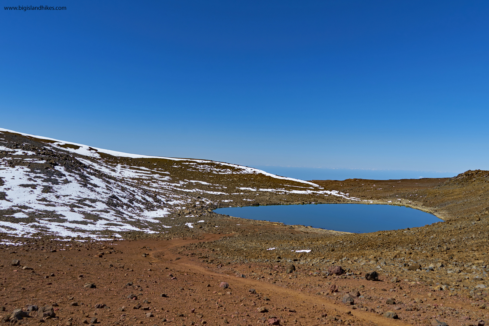
Lake Waiau
Persevere through the 13,000 foot mark and spot the trail to Lake Waiau. This short diversion is well worth your effort. Contained within the Pu’u Waiau cinder cone at an altitude of 13,022 feet, this lake is the highest in the Pacific Basin and the Big Island. The lake is very shallow, and is a site that is sacred to the Hawaiian people. Stay away from the lake and do not disturb religious offerings around the lake. Radiocarbon dating of samples at the bottom of the lake indicate that it was clear of ice 12,600 years ago. What feeds this lake? For some reason, water collects in the basin created by the erosion of Pu'u Waiau. The reason why it does not percolate so easily into the lava rock like water does throughout the rest of the island is unknown. Two theories attempt an explanation: either sulfurous steam altered the volcanic ash to low-permeability clay soil; or explosive interactions between rising magma and water (phreatic eruptions) formed exceptionally fine ash that also would reduce the permeability of the lake bed. Regardless, sit and marvel at this lake sitting in such a dry, unforgiving place.
Continue past the trail intersection for Lake Waiau for 1/2 mile and reach the road. After a quiet hike of solitude through an alien landscape, reaching this road is jarring. Quickly walk along the road for almost a mile and be very wary of rubber-necking drivers (ironically, this might be the most dangerous section of this “trail.”). There are a few places where it seems like you can leave the road and climb directly uphill, but you’ll just exacerbate erosion on these loose slopes. When you reach the summit area and can see the parking area, leave the road and hike 1/3 mile to the red-tinted summit cinder cone on a trail. Bask in the view. Retrace your steps to descend. It is disrespectful to the Hawaiian people to stand directly on the summit.

Mauna Kea Summit View